This section of the MAPO site is intended as a learning tool for those who may be unfamiliar with MAPO or with metropolitan planning organizations (MPOs).
MPOs in Minnesota
Metropolitan Planning Organizations (MPO) are entities designated by law with the lead responsibility for the development of a metropolitan area’s transportation plans and to coordinate the transportation planning process. All urban areas over 50,000 in population are required to have an MPO if the agencies spend Federal funds on transportation improvements.
MAPO was established in 2012 in response to the 2010 U.S. Census, which designated the Mankato/North Mankato region as an urbanized area.
There are eight (8) Metropolitan Planning Organizations in Minnesota:
- Duluth/Superior Metropolitan Interstate Council
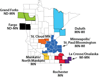
- Fargo-Moorhead Metropolitan Council of Governments
- Grand Forks/East Grand Forks MPO
- La Crosse Area Planning Committee
- Mankato/North Mankato Area Planning Organization
- Rochester/Olmsted Council of Governments
- St. Cloud Area Planning Organization
- Twin Cities Metropolitan Council
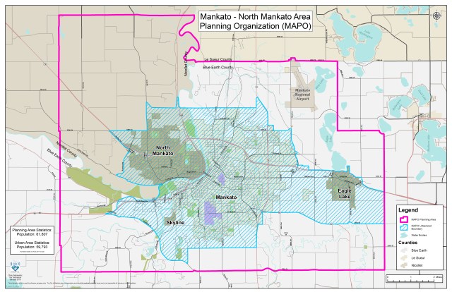
MAPO Planning & Urbanized Area
The Mankato/North Mankato metropolitan statistical area (MSA) is centrally located in south central Minnesota, positioned in the scenic beauty of the Minnesota River Valley. The area enjoys convenient road, rail, and water access to regional goods and resources, including agriculture, mining, timber, metals, and finished products. The area shares economic and labor ties with several regional centers, including Minneapolis-St. Paul, 75 miles to the northeast, and Rochester, 84 miles to the east. Major industries include: Health Care, Printing & Related Support Activities, Educational Services, Social Assistance, Machinery Manufacturing, Nursing & Residential Care Facilities, Telecommunications, Food Manufacturing, Primary Metal Manufacturing, and Agricultural Services
The population of the entire MAPO planning area is about 61, 807. The population for the MAPO urban area is about 59,793 (American Community Survey 2017 5-year estimate). The planning area covers about 131 square miles.
Organizational Structure & Joint Powers Agreement
MAPO is an intergovernmental forum for communication and collaboration on local transportation issues. Having a variety of local representation at the table helps ensure that local transportation planning is continuing, cooperative, and comprehensive (3C).
MAPO’s Technical Advisory Committee (TAC) is made up of stakeholders and transportation professionals from the counties of Blue Earth and Nicollet, cities of Mankato, North Mankato, Eagle Lake, Skyline, townships, other stakeholders. Representation includes MnDOT District 7, Region Nine, School District, Transit, and Minnesota State University, Mankato.
The TAC makes formal recommendations to the MAPO Policy Board, which is made up of elected representatives appointed by the MAPO’s member jurisdictions, listed below:
- 1 member Eagle Lake
- 1 member Blue Earth County
- 1 member City of Mankato
- 1 member Nicollet County
- 1 member City of North Mankato
- 1 member representing the MAPO Townships (Belgrade, LeRay, Lime, Mankato, & South Bend)
For more information on these entities and their partnerships as they relate to MAPO, please review the MAPO Joint Powers Agreement.
Funding & Budget
The operating budget for MPOs is comprised of federal, state, and local sources. Funds are spent on staff resources and consultant services. Typical budget items include corridor studies, intersection control evaluations, various plan/studies/reports, staff time/training, and other required transportation-related work. Each year’s budget and project list are outlined within the annual Unified Planning Work Program, located at the Planning Documents section of this site.

MAPO’s total operating budget for 2019 is $371,589. This total is derived from a variety of federal, state, and local sources.

Work Products
MAPO generates a broad variety of transportation-related work products. Past studies, plans, and reports can be reviewed at the Planning Documents section of this site and include:
- Unified Planning Work Program (updated annually)
- Long Range Transportation Plan – LRTP (updated every 5 years)
- Transportation improvement program – TIP (updated annually)
- Corridor Studies
- Intersection Control Evaluations (ICEs)
- Wide range of local planning studies, plans, and reports.
- Technical assistance to member municipalities related to funding opportunities, planning and/or research projects, and grant applications
- Assistance to the Mankato Transit System (MTS)
Ongoing Work
Explore the Public Participation section of this site for ways to stay informed and engaged with the MAPO’s ongoing work.
