
MAPO has partnered with Minnesota State University, Mankato, the City of Mankato, and Blue Earth County to study pedestrian connectivity on Stadium Road between the intersections of Ellis Avenue and Warren Street. The corridor is approximately 1,400 feet and services both university and non-university pedestrian, bicyclist, and automotive traffic. The study goal is to develop potential solutions for improved travel conditions for all modes.
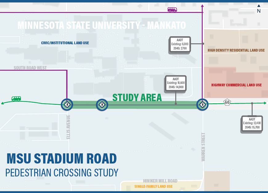
The corridor also operates as a critical multimodal connector with on-street bike lanes, sidewalks and pedestrian crossings, and bus stops for the Mankato Transit System which operates both routes connecting the region to MSU,M as well as specific “U-Zone” campus routes. Additionally, nearly 2,500 parking spaces and the school’s athletic complex resides south of Stadium Road as it bisects the campus, creating a barrier for students and visitors to access athletic events and student commuters to travel between the parking lots and main campus area. All the transportation modes require right-of-way space to safely and efficiently operate along, and across, Stadium Road which supports the access and vitality of MSU,M for students, faculty/staff, and visitors.
With so many competing needs, safety issues have arisen over the last ten years. A process rooted in quantitative analysis and community input will assist with understanding the mobility relationships and creative solutions to improve the safety, comfort, and reliability of Stadium Road for those walking, bicycling, taking transit, and driving.
How do I comment or ask questions?
•Submit comments online HERE.
•Email to ctalamantez@mankatomn.gov
•Call (507) 387-8389
•Send comments via U.S. mail to MAPO at 10 Civic Center Plaza, Mankato, MN 56001
•Place comments in dropbox located in front of MAPO offices (address above)
•Tweet @MinnesotaMAPO
Interpretation, translation, or disability accommodation services are available free of charge. Please contact MAPO staff via any of the listed methods to request services
